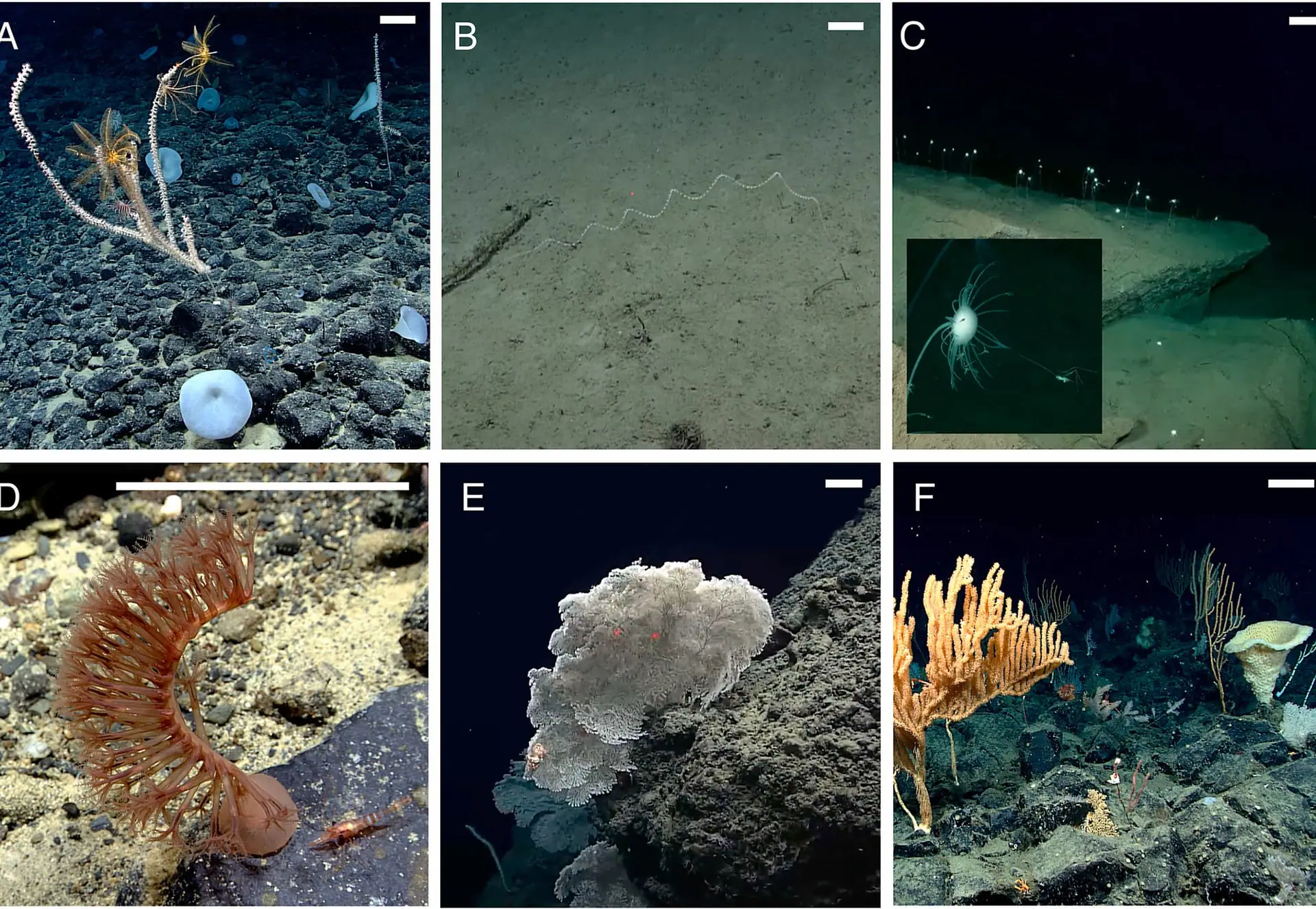
A study of 75 hours of dive footage of sponges and corals in Alaska's deep sea found that which communities formed where was linked more strongly to the surrounding currents and water masses than to depth. The paper, by Lara Maleen Beckmann, a Ph.D. candidate at the University of Gothenburg, and colleagues, appears in volume 229 (June 2026) of Deep Sea Research Part I. NOAA Ocean Exploration featured the study on 18 June. The team judged eight sites, including places with more than 20 sponges per square metre, to qualify as high-density vulnerable marine ecosystems (VMEs).
What was studied in Alaska's deep sea, and how?
The team reviewed 75 hours of video and data from the 2023 Seascape Alaska expeditions of NOAA Ship Okeanos Explorer, including dive recordings from previously unexplored sites between 380 and 3,200 m deep.
According to NOAA's expedition page, the six Seascape Alaska expeditions ran from May to October 2023, and the two whose names refer to remotely operated vehicle (ROV) exploration were EX2304 in the Aleutian Islands and EX2306 in the Gulf of Alaska. The paper's graphical abstract (a one-image summary of the study) shows that the team examined 15 ROV dive locations from those two expeditions.
| Expedition | Dates | Focus | Ports |
|---|---|---|---|
| EX2304 (Seascape Alaska 3) | 14–25 July 2023 | ROV exploration and mapping in the Aleutian Islands | Kodiak → Dutch Harbor |
| EX2306 (Seascape Alaska 5) | 23 August – 16 September 2023 | ROV exploration and mapping in the Gulf of Alaska | Kodiak → Seward |
Alaskan waters contribute the largest area to the U.S. Exclusive Economic Zone, yet NOAA's page on the 2023 expeditions counts them among the least explored areas in the United States and says current mapping data cover only 34% of the seafloor there.
What did 75 hours of footage reveal?
The footage contained 15,531 coral and sponge observations. The team sorted them into morphotypes, groups of organisms that share physical characteristics, and arrived at 74 coral and 90 sponge morphotypes, 164 in all. Dominant species ranged from deepwater corals to sticklike carnivorous sponges.
63% of the morphotypes were seen at only one dive site. The team also expanded the known ranges of multiple species. The release speaks of "over 164" morphotypes, but the breakdown in the graphical abstract adds up to exactly 164, so we use the graphical abstract's figure here.
| Item | Value | Source |
|---|---|---|
| Video and data reviewed | 75 hours | Release and graphical abstract |
| ROV dive sites | 15 | Graphical abstract |
| Depth of previously unexplored sites | 380–3,200 m | Release |
| Coral and sponge observations | 15,531 | Graphical abstract |
| Morphotypes | 74 coral and 90 sponge (164 in all) | Graphical abstract |
| Morphotypes seen at only one site | 63% | Release |
| Sites qualifying as high-density VMEs | 8 | Release and graphical abstract |
| Density at cladorhizid sponge grounds | Up to 20.68 individuals per square metre | Graphical abstract (the release says "over 20" at some sites) |
Diversity and abundance peaked at the edges of the oxygen minimum zone, a layer very low in oxygen, which the graph in the graphical abstract marks as water with less than 1.43 mg of oxygen per litre.
If not depth, what were the communities linked to?
The composition of a dive site's community was most strongly associated with the currents and water mass structure around it. A water mass is a body of seawater with similar properties, such as temperature and oxygen.
One might expect depth or the distance between sites to structure these communities, but the results showed a different pattern: sites within the same current or water mass tended to host similar assemblages even at different depths. The figures in the release show three scenes for each water mass or current.
| Panels | Water mass or current at the site |
|---|---|
| A–C | Lower Circumpolar Deep Water or Pacific Deep Water |
| D–F | Pacific Subpolar Intermediate Water |
| G–I | Continental shelf sites influenced by the Alaska Coastal Current |
| J–L | Sites associated with the Aleutian North Slope Current |
These findings provide one of the first quantitative demonstrations of these ecological patterns in Alaskan deep waters. The importance of oceanographic structure compared to other factors like depth reinforces the need to incorporate oceanographic structure when interpreting deep-sea biodiversity patterns.
— Lara Maleen Beckmann (Ph.D. candidate, University of Gothenburg)
NOAA expects that knowing which variables shape seafloor communities will help researchers predict the types of animals that may be found at similar sites. NOAA adds that this knowledge also helps researchers and managers understand how habitats will move and change as ocean conditions shift.
Eight sites judged to be vulnerable marine ecosystems
Sponges and corals create habitat for a wide range of other animals, including commercially important species such as rockfish, king crabs and cod. From the dive sites of the Seascape Alaska expeditions, the team identified eight that qualified as high-density VMEs. This was the team's assessment; the release does not say the sites have been officially designated.
At some sites the researchers found more than 20 sponges per square metre. The graphical abstract says the eight sites include unique grounds of cladorhizid sponges (family Cladorhizidae) with up to 20.68 individuals per square metre. In the paper, the authors note that knowing which areas harbour VMEs helps inform effective fisheries management and stewardship measures.
The graphical abstract shows photographs of three sites: a coral garden at Uliaga Mound, a Cladorhizidae forest at Big Bend Canyon and a coral and sponge wall at Gumby Ridge. NOAA's release says records of such communities provide an essential ecological baseline for understanding biodiversity in poorly sampled regions, and a foundation for future research, stewardship and fisheries management.
Public footage becomes another researcher's discovery
The raw material for this study was footage from NOAA Ocean Exploration's expeditions. NOAA stressed that publicly available high-definition recordings from the deep sea support research on these topics around the world. Beckmann and others also used NOAA Ocean Exploration footage in another paper, published in February 2026, on deep seamounts in the North Atlantic.
Dive footage from NOAA and others has also produced a study showing that fish become longer and more eel-like with depth around Puerto Rico. The animals and regions differ, so the two cannot simply be compared, but the finding that sponge and coral communities tracked water masses more closely than depth suggests that depth alone may not explain where deep-sea life lives.
We were able to read only NOAA's release and the paper's graphical abstract, so we could not check the paper's statistical methods, the criteria used to judge VMEs, or the location and depth of each of the eight sites. The release also does not say which of the 164 morphotypes are new range records, so we will hold off on naming specific species until we can read the paper.