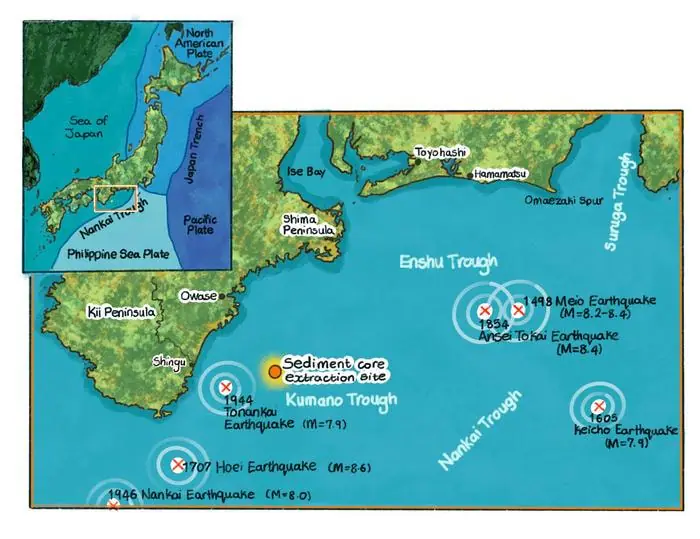
A 40 cm column of mud taken from 2,080 m deep in the Kumano Trough, off Japan's Kii Peninsula, contains seven "event layers" that cannot be told apart by eye, and most of them do not show up on X-ray CT images either. Professor Yusuke Yokoyama of the University of Tokyo's Atmosphere and Ocean Research Institute (AORI) and colleagues radiocarbon-dated the organic carbon in the mud every 0.5 to 1.0 cm and picked out the places where the ages run backwards, older on top of younger. The team links some of these layers to Nankai Trough earthquakes such as the 1707 Hoei earthquake.
What was found in the Kumano Trough mud?
The layers appear to be old mud that slid off the seafloor slope, was carried downslope and settled again. The paper calls them event layers and counts seven of them in the core.
The Kumano Trough is a forearc basin off the Kii Peninsula, a seafloor depression formed as the Philippine Sea Plate sinks beneath the Eurasian Plate. Its broad floor lies at around 2,000 m, and on the landward side it is bordered by a shelf less than 10 km wide and a steep slope. The core was collected in 2012 during cruise KT-12-34 of the research vessel Tansei-maru, using a multiple corer that pulled a 40 cm column of sediment from the western part of the basin. At 2,080 m, the site is deeper than three Tokyo Skytree towers stacked on top of each other.
The five-author paper by Akiko Omura, Yokoyama and colleagues was published on 9 November 2026 in the journal Radiocarbon, as one of the selected papers from the 25th International Radiocarbon Conference held in Krakow, Poland, in 2025. It is open access, so anyone can read it in full.
We found several new geological layers that were not visible before, derived from submarine landslides possibly triggered by earthquakes in the Nankai Trough.
— Yusuke Yokoyama (Professor, Atmosphere and Ocean Research Institute, The University of Tokyo)
Why were the layers invisible?
The mud that slid in was made of the same material as the mud already lying there, so in most layers there was no difference in colour or grain size to see.
The core is unconsolidated clayey silt. Apart from a gradual change at about 4 cm depth from brownish black to olive black, it shows no structure visible to the naked eye, and the paper describes it as "homogeneous hemipelagic mud". Hemipelagic mud builds up from particles sinking from near the sea surface and fine particles carried from land.
The usual tool for tracing past earthquakes on the seafloor has been turbidites: deposits left by murky underwater flows (turbidity currents), often set off by submarine landslides, which generally show coarse grains at the bottom grading up into finer ones. The Kumano Trough core shows no sequence typical of turbidites. Only two event layers lined up with brighter bands on the X-ray CT images, a bright layer between 10 and 16 cm (layer 3) and a finely laminated layer (layer 5, slightly offset), while the other five are invisible on CT as well and appear only in the dating results.
Because the redeposited sediments are the same as the materials below, the chemical and structural features were indistinguishable, making the event layers invisible.
— Yusuke Yokoyama (Professor, Atmosphere and Ocean Research Institute, The University of Tokyo)
How were ages measured every 0.5 to 1 cm?
The team measured carbon-14 in the total organic carbon of the mud at 0.5 to 1.0 cm intervals, without gaps, from the top of the core to the bottom.
The measurements were made on the accelerator mass spectrometer at AORI. Carbon-14 is radioactive carbon with a half-life of 5,730 years; it makes up only one-trillionth of natural carbon, living things take it up while alive, and after death it decays at a fixed rate, which allows dating back 50,000 to 60,000 years.
Seafloor mud is normally dated with the fossil shells of planktonic foraminifera, tiny shelled organisms, but mud in the forearc basins along the Nankai Trough often contains too few of them, which ruled out fine-scale dating. Organic carbon in bulk mud can be dated from small samples, but because it includes old carbon it gives ages that are too old. Where foraminifera could be recovered, the team dated 0.75 to 2.35 mg of shells and compared the result with the organic-carbon age from the same layer. In normal layers the organic carbon came out 920 to 1,100 years older, and the team worked out the offset from the foraminifera layer by layer to convert the organic-carbon readings into depositional ages.
Put in order, the 40 cm of mud turned out to cover the past 600 years or so. That is about 15 years per centimetre on average, so each 0.5 to 1.0 cm sample covers roughly 8 to 15 years. The oldest dated part of the core, at 37 to 38 cm, dates to around 1440, while values from foraminifera at 2.0 to 3.5 cm near the surface, compared with records in corals from Ishigaki and Kikai islands, showed that this mud was deposited after 1965.
How did the layers with reversed ages form?
Layers older than the ones beneath them can be read as old mud from elsewhere on the seafloor that was carried in by a flow and laid on top of younger mud. The marine origin of the organic matter in that mud helped narrow down the cause.
In some layers the organic-carbon age was up to 700 years older than in lower layers. The age gap between event layers and normal layers exceeds the average measurement error of ±100 years. The paper cites earlier work near the Shingu Submarine Canyon, where turbidites from roughly the past 100 years were linked to historical earthquakes and severe floods, and suggests that turbidity currents may also have reached this core.
Old carbon can also arrive when a flood washes sediment in from land, so the team measured the stable carbon isotope ratio (δ13C) and the carbon-to-nitrogen ratio (C/N) every 1 cm as well. The C/N ratio stayed around 8 and δ13C between −20 and −22‰, within the range of marine organic matter. Marine organic matter typically has a C/N ratio below 10, and the paper finds no sign of organic matter from land plants mixed in. It concludes that the age reversals came from submarine slope failures rather than floods, and that a flood origin is unlikely. The paper also lists storm-driven resuspension of seafloor sediment as a trigger of turbidity currents, but its conclusions do not address storms.
Which earthquakes do the seven layers match?
The only match the paper states firmly is between layer 3 and the 1707 Hoei earthquake; the others are described only as possible.
| Event layer | Earthquakes linked in the paper | Wording in the paper |
|---|---|---|
| Layers 1 and 2 | The 1944–46 earthquakes (written as "Tokai-Tonankai earthquake" in the paper), and the 1854 Ansei Tokai earthquake | possible (may) |
| Layer 3 | The 1707 Hoei earthquake | correlated |
| Layers 4 and 5 | The 1707 Hoei earthquake, or a minor submarine earthquake | possible (may) |
| Layer 6 | The 1605 Keicho earthquake | possible (could) |
| Layer 7 | Not discussed in the text | Labelled "Event layer?" with a question mark in the figure |
. Orange bands are event layers (excluding "Modern" at the top). Image: A. Omura, Y. Yokoyama, S. Hirabayashi et al. 2026 / Radiocarbon (CC BY 4.0)")
Japan's Headquarters for Earthquake Research Promotion notes that the source area of the Hoei earthquake may have extended further west than that of the 1946 Showa Nankai earthquake and others. Around 15 cm, where layer 3 begins, δ13C shifts slightly, and the paper suggests the seafloor environment might have changed because of an earthquake at that time. The figure also includes a line for the 1498 Meio earthquake, but the text does not tie it to any layer.
Two points where the news release and the paper differ
The first difference is the time span: the English news release quotes Yokoyama as saying some layers matched "written historical records of submarine earthquakes from the 13th to the 20th century". The paper's abstract instead reports good correlation with "historical natural disasters after the 15th century", and the oldest part of the core dates to around 1440. Within this core, the comparison with historical records is more accurately described as covering the 15th century onward.
The second difference is the cause: the English release lists severe floods, storms and submarine earthquakes as events that disturbed the mud, and the University of Tokyo's Japanese release, judging by the title we could confirm through a repost, mentions a "tsunami and flood history". The paper's conclusion is narrower: because the organic matter is marine, it considers floods unlikely and points to submarine slope failures as the cause (storms are not addressed in its conclusions).
What one core can and cannot tell us
The study rests on one 40 cm core from a single site in the Kumano Trough, and it has not yet been checked whether the same layers appear elsewhere. Layer 3 is correlated with the Hoei earthquake and layers 4 and 5 are also suggested as possibly linked to it, so in our view this single core cannot yet settle whether one earthquake left several layers or whether they record separate events.
Even so, the method can pick up a record where no visible turbidite exists, and its value becomes clearer next to Japan's long-term earthquake assessment. According to the Headquarters for Earthquake Research Promotion, large earthquakes have struck the Nankai Trough at intervals of about 90 to 270 years over the past 1,400 years; the next one is expected to be of magnitude 8 to 9, and its 30-year probability is placed in the highest category, Rank III. As of November 2026, about 82 years have passed since the 1944 Showa Tonankai earthquake and about 80 years since the 1946 Showa Nankai earthquake. More records of when past earthquakes struck, and how far their effects reached, would give such assessments a firmer footing. According to the release, Yokoyama is interested in extending the work more widely across the Kumano Sea and beyond.