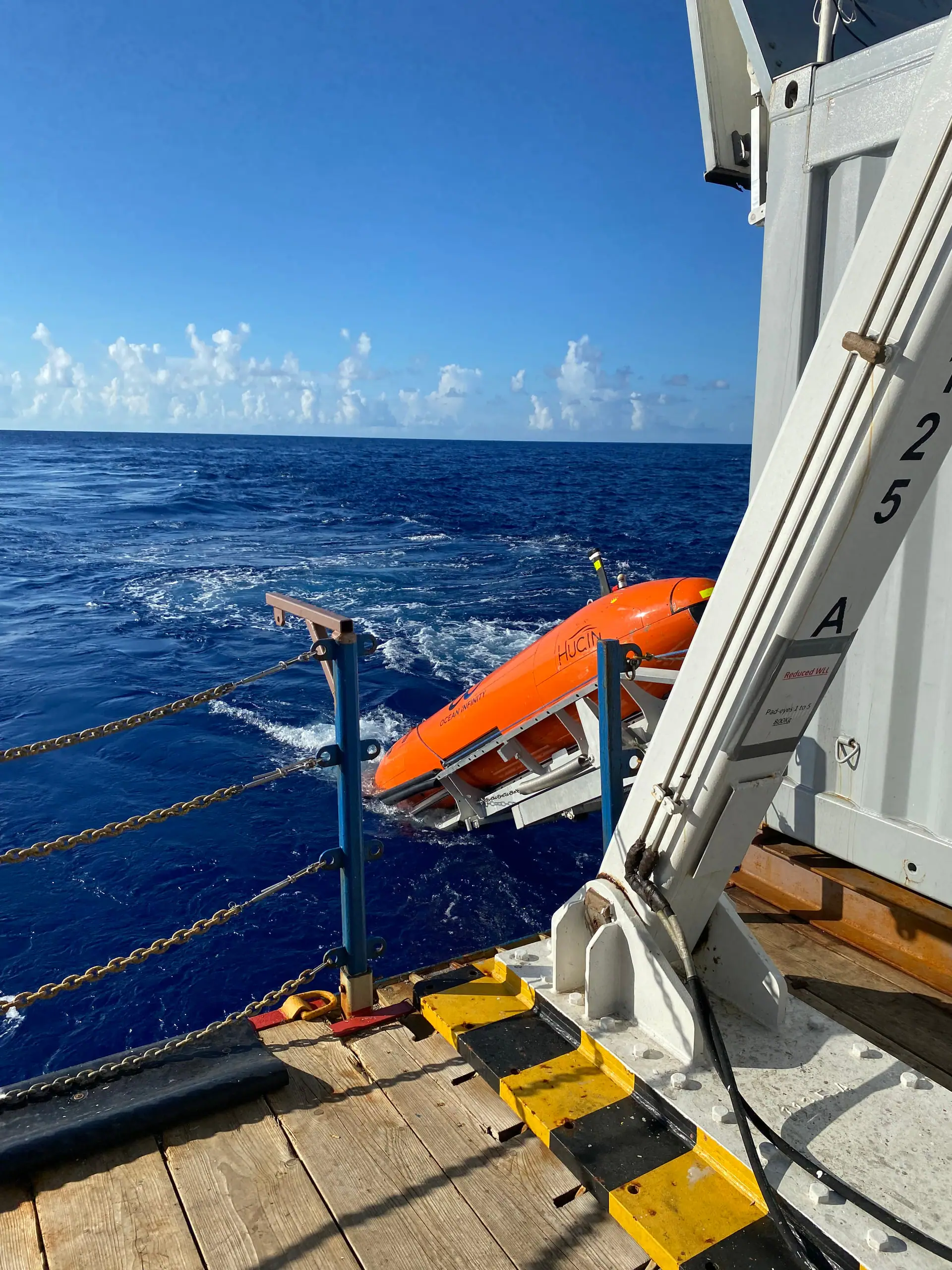
NOAA Ocean Exploration is running trials off the main Hawaiian Islands from 2 to 16 November 2026 with three autonomous underwater vehicles (AUVs) aboard NOAA Ship Okeanos Explorer. All three are rated to a depth of 6,000 m, and one of them, a HUGIN 6000, is the largest AUV ever brought aboard the ship.
What is NOAA testing off Hawaii?
NOAA Ocean Exploration is at sea on Okeanos Explorer from 2 to 16 November for its 2026 Technology Demonstration (expedition EX2701). The expedition page sums up its goal as testing and evaluating the operational use of AUVs to expand NOAA Ocean Exploration's at-sea data collection capabilities. The ship departed Honolulu, and the team plans field trials offshore the main Hawaiian Islands.
The main purpose is to test the use and integration of AUVs in the routine operations of Okeanos Explorer, with the ultimate goal of improving how data are collected at sea. Because an AUV's instruments can be swapped, it can be adapted to a range of data needs, such as mapping at higher resolution than bathymetry measured from the ship. What the team learns will inform operations on Okeanos Explorer and also future operations on its eventual successor, NOAA Ship Discoverer.
What will the HUGIN 6000 and the Orpheus vehicles do?
The expedition deploys two types of AUV, funded through the NOAA Ocean Exploration Cooperative Institute (OECI). There is one HUGIN 6000 and there are two Orpheus vehicles, which are built, owned and operated by Orpheus Ocean. Both types have flexible payloads, so their instruments can be adjusted for different tasks.
The HUGIN 6000 is rated to 6,000 m (3.7 miles) and can be deployed for up to 48 hours at a time. Its instruments are listed below, and it is the largest AUV ever brought aboard Okeanos Explorer.
- Multibeam sonar and synthetic aperture sonar (SAS)
- A sub-bottom profiler, which probes sediment layers beneath the seafloor with sound
- A magnetometer and a camera
- A CTD sensor, which measures conductivity (used to calculate salinity), temperature and depth
The two Orpheus vehicles are also rated to 6,000 m, and these compact, lightweight vehicles will carry cameras and pushcores, tubes that are pushed into the seafloor to take sediment samples. An early prototype of Orpheus was tested aboard Okeanos Explorer during the 2021 Technology Demonstration.
| Vehicle | Number | Depth rating | Main instruments on this expedition | Role |
|---|---|---|---|---|
| HUGIN 6000 | 1 | 6,000 m | Multibeam sonar, synthetic aperture sonar, sub-bottom profiler, magnetometer, camera, CTD | Wide-area mapping along lines up to 150 km |
| Orpheus | 2 | 6,000 m | Cameras, pushcores | Detailed surveys of set areas with images and samples |
According to NOAA's explainer, synthetic aperture sonar as a technique sends out continuous pulses and combines the returns so that the transducer array behaves as if it were longer than it really is. By measuring the same spot many times, it can map a site at 30 times the resolution of traditional side scan sonar, though it is expensive to operate and usually covers less ground than side scan sonar. The expedition page does not give the resolution of this HUGIN.
How will the two-week expedition unfold?
The first 48 hours are a true shakedown of equipment and operating procedures. The team will get used to a new launch and recovery protocol for the two AUV systems and will calibrate and test the vehicles after their long journeys to the ship.
After the shakedown, operations using multiple vehicles will be tested. The HUGIN 6000 will carry out multibeam and SAS surveys along preprogrammed lines up to 150 km (93 miles) long, while the Orpheus vehicles explore set areas in more detail by collecting photomosaic imagery and sediment cores.
Unlike remotely operated vehicles (ROVs), which are tethered to a ship, AUVs have no physical connection to their operators. In NOAA's explainer, an ROV sends video up its tether to a control room almost instantly, whereas an AUV stores its data, including images, on onboard computers until it is recovered. Some AUVs, such as URASHIMA 8000, also send status information such as battery level and depth to the ship by acoustic communication.
Why build AUVs into an exploration ship?
NOAA Ocean Exploration says the lessons of the 2026 Technology Demonstration will take it one step closer to a new way of operating that combines AUV, ROV and shipboard data collection. These lessons are to inform operations not only on Okeanos Explorer but also on Discoverer.
There is a gap between the detailed, small-scale data an ROV collects and the large-scale mapping done by the ship, and NOAA sees potential for AUVs to bridge it. That, in NOAA's view, would expand knowledge of the ocean environment and make studying it more efficient. Once complete, and with input from partners, crew and the science team, the expedition will also serve as a foundation for planning future deep-water AUV expeditions on NOAA ships.
| Survey tool | Strengths | Limitations |
|---|---|---|
| Ship (hull-mounted multibeam sonar) | Mapping wide areas | Far from the seafloor, so lower-resolution terrain data |
| AUV | Covering fairly wide areas at high resolution from near the seafloor | Usually cannot take rock samples (Orpheus carries pushcores) |
| ROV or crewed submersible | Imaging and sampling with cameras and arms, pinpoint surveys | Not suited to wide areas; an ROV's range is limited by its tether |
We compiled this table from NOAA's expedition page and the comparison of ships, AUVs and submersibles on the Japan Agency for Marine-Earth Science and Technology (JAMSTEC) page about URASHIMA 8000. JAMSTEC's comparison describes AUVs as vehicles that basically survey without sampling, but the Orpheus vehicles on this expedition will carry pushcores and collect sediment samples as well.
How does it compare with Japan's AUV URASHIMA 8000?
One Japanese example of an AUV is JAMSTEC's Deep Sea Cruising AUV URASHIMA 8000. According to JAMSTEC, development of URASHIMA began in 1998, conversion to the 8,000 m class started in 2022, and in 2025 the vehicle successfully completed a navigation test at a depth of 8,000 m. Flying about 120 m above the seafloor, it can observe the seabed at a resolution of roughly 1 m or better and can also obtain structural data down to a few tens of meters below the seafloor.
| HUGIN 6000 (NOAA demonstration) | URASHIMA 8000 (JAMSTEC) | |
|---|---|---|
| Depth rating | 6,000 m | 8,000 m class (successful navigation test at 8,000 m in 2025) |
| Main observations | Multibeam, synthetic aperture sonar, sub-bottom profiler and more | High-resolution seafloor terrain and sub-seafloor structure |
| Use now and next | Trial of integration into routine operations of an exploration ship | Expected to be used for detailed surveys of trench areas |
In our view, both play a similar in-between role, surveying in finer detail than ship-based soundings and over wider areas than an ROV. The main purpose of NOAA's current demonstration is to test whether AUVs can be built into the routine operations of an exploration ship, and operations using multiple vehicles are being tested as part of that.
When and where will the results be available?
Data collected on Okeanos Explorer expeditions are submitted to NOAA's public data archives within 120 days of the expedition's end, after which anyone can access them through the NOAA Ocean Exploration Data Atlas. Data from the 2026 Technology Demonstration also contribute to the National Strategy for Exploring, Mapping, and Characterizing the United States Exclusive Economic Zone and to Seabed 2030 (an international effort to map the world's seafloor).
What this article describes is the plan as of the start of the expedition. The expedition page does not say who operates the HUGIN 6000 (its related-links section at the bottom of the page lists Ocean Infinity and Orpheus Ocean). Whether the survey lines and launch procedures went as planned, and whether operating the HUGIN and Orpheus vehicles in combination worked, will have to wait for post-expedition reports and the data release. Among other NOAA Ocean Exploration research, Deep Sea Log has also covered a study of sponge and coral communities in the deep waters off Alaska.
This article is a translation of the expedition page that NOAA Ocean Exploration published on 29 October and updated on 2 November, the first day of the expedition, with our own commentary added, including an explainer on AUVs and a comparison with a Japanese AUV. The expedition is still under way, and no results have been released yet.